Photo: Crystal Eye Studio
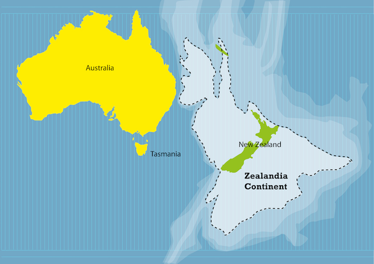
In school, you were probably taught about seven continents—Africa, Asia, Antarctica, Australia, Europe, North America, and South America. But did you know that, according to geologists, there's another hidden continent? Zealandia, a term first coined in 1995, is the name of a piece of sunken continental subcrust off the coast of Australia. And now, researchers are saying that it qualifies as its own continent.
In a study published in GSA, a group of top-notch scientists have come together and pooled 10 years of research proving that Zealandia is, geologically, its own continent. Bruce Luyendyk, a geophysicist at the University of California at Santa Barbara, came up with the name Zealandia in 1995 to describe New Zealand, New Caledonia, and submerged pieces of crust that broke off the Gondwana supercontinent and separated from Australia 60 to 85 million years ago. While Luyendyk wasn't involved in the study, he supports their findings. “These people here are A-list earth scientists,” said Luyendyk, “I think they've put together a solid collection of evidence that's really thorough.”
The study states that New Zealand and New Caledonia are not just island chains, but part of the Zealandia continent, which is a 1.89 million-square-mile piece of continental crust. The researchers looked at the diversity of igneous, metamorphic, and sedimentary rocks within the slab, as well as height differences relative to the ocean floor, and well-defined limits around large areas. They also looked at recent satellite-based elevations and gravity maps to see that the region did appear unified. This led to the conclusion that Zealandia can indeed be classified as a continent.
Only 6% of the entire continent—which is about the size of greater India—pokes out above water, which is part of what kept it off the radar for so long. “The scientific value of classifying Zealandia as a continent is much more than just an extra name on a list,” the researchers write. “That a continent can be so submerged yet unfragmented makes it a useful and thought-provoking geodynamic end member in exploring the cohesion and breakup of continental crust.”
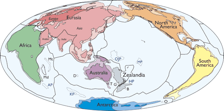
Simplified map of Earth’s tectonic plates and continents, including Zealandia. (Photo: N. Mortimer et al./GSA Today)
h/t: [IFL Science!]
Related Articles:
Interactive Map Lets You Pinpoint Your Address on Earth Millions of Years Ago
Map Reveals Where Modern Countries Would Be Located If Pangea Still Existed
Eye-Opening “True Size Map” Shows the Real Size of Countries on a Global Scale

