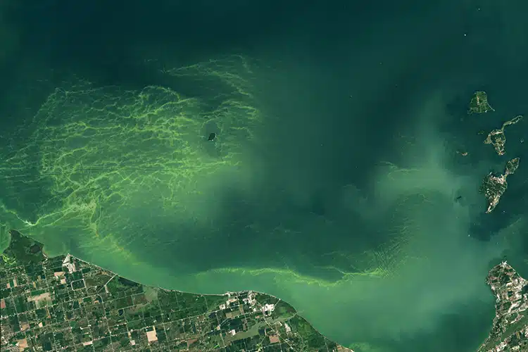
The bloom spread across Lake Erie as captured from a satellite. (Photo: OLI-2/Landsat-9/USGS via NASA Earth Observatory)
Anyone who lives near the Great Lakes of North America is likely familiar with the green algae that can encroach upon its deep blue waters. The Great Lakes hold a fifth of Earth's fresh surface water. They are incredibly valuable aquifers and ecosystems, hosting plenty of plant and animal life. But like all ecosystems, they change with the seasons and the times.
Scientists track these changes in many ways, perhaps most dramatically through satellite imagery. An image taken by NASA's OLI-2 onboard the Landsat-9 captured one of these monumental environmental shifts in August 2024—a massive emerald green algal bloom stretching across a portion of Lake Erie.
Algal blooms are common in the Great Lakes, but tracking them can provide scientists with important data on the health of our water systems as well as the impacts of climate change. They vary from year to year. On August 13, 2024, NASA's Operational Land Imager-2 camera captured data on the surface of the deep lake. The water appears almost teal, but swirling through one large region are emerald light streaks. This is an algal bloom stretching 320 square miles of the lake's surface. Although the camera did not snap a likeness, the bloom was thought to peak around August 22 at a massive 660 square miles.
Blooms are affected by temperature, rainfall, and runoff, among other factors. The blooms are composed of bacteria, mostly the Microcystis cyanobacteria. Environmental conditions determine how far and long the blooms flourish. While they may look beautiful, the mini creatures produce a toxin known as microcystin.
According to NASA's Earth Observatory, this toxin “can cause liver damage, numbness, dizziness, and vomiting.” Humans are typically advised to avoid water boasting blooms or high toxin levels. For scientists, tracking bloom appearances and expansion can shed light on the wider climate. They will soon also be able to draw on data from NASA’s new PACE (Plankton, Aerosol, Cloud, ocean Ecosystem) satellite. These high-tech tools help probe and ultimately protect an irreplaceable aquifer.
h/t: [IFL Science]
Related Articles:
Tourist Causes a “World Changing” Event by Dropping Cheetos Into North America’s Largest Cave
Fossilized Flowers From Greenland Reveal It Was a Green Tundra Less Than 1 Million Years Ago